
The evidence assessed

|
The evidence assessed
|
|
Finding Fulford
The interpretation of the battle is based on the literature and the shape of the land. It will never be possible to work out the exact course of the battle but the research by the Fulford Battlefield Society will investigate the terrain and continue to locate finds to help shed light on the events of 20 September 1066.
Conflict Archaeology is a new subject. The first university course specialising in battlefield archaeology begins in 2006. The location of an ancient battlefield is difficult to prove.
Our task has been more like a piece of police forensic work. But this ‘crime scene’ is nearly 1000 years old so direct evidence is hard to find. Nothing has been found at Hastings or Stamford Bridge.
This is what we have done to identify the site and the course of the battle of Fulford.
This has provided useful clues about the location but is not definitive. It has allowed the leaders, likely approach routes, the composition and size of the armies, weapons and tactics employed to be assessed. It was also useful once we had studied the ancient landscape to look again at the literature and discover that the story in some sagas make even more sense.
Examine all the landscape and geological evidence
Early maps help to show that key features around Fulford have not moved. This is confirmed by the local geology which explains the reason for the wet-lands to the east and Ings to the west of the Fulford glacial moraine deposited 15,000 years ago. Two moraines meet at Fulford. The ‘Escick’ and the ‘York’ moraines. The breach provides a drain for the Walmgate, Heslington and Fulford wet-lands. This location fits well with the literature and other work shows that the layout has been remarkable stable. Almost as important, the geology precludes most other possible sites.
The deposits left by the last ice sheet created the high ground that links York to Fulford at 'Foul Ford''.
Extensive core sampling has allowed the battlefield of 1066 to be envisaged. It is remarkably similar to the present with 4 exceptions.
Landscape archaeology
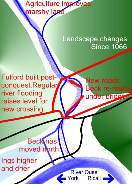
A study of how the landscape has developed reveals that the place known as Gate Fulford was about 1 km from the crossing and the present village of Fulford is a post-conquest settlement. The move to the new location was probably made possible by the build-up of silt caused by the river flooding. This made a new crossing possible.
The shape of the Beck has changed. The shape of the original beck also fits the literature as it explains why the English were rather slow to respond to Harald's crossing of the beck beside the river.
Environmental archaeology
Analysis of soil samples in the area has allow the shape and the texture of the land to be assessed. Much of the land can be shown to have been waterlogged in 1066 which helped to localise the site. We can say that the modern Ings were not suitable territory for the battle as much of the land was waterlogged.
The Environment
Understanding how the land has been used has helped to date the landscape. The number of woody species in hedges can, for example, give an indication of the age of a hedge. There appear to be some extremely old hedges on the site. Some sections might even date from the time of the battle reinforcing the view that the key parts of the landscape have not change.
It is possible that small fragments of armour, parts of weapons and projectiles might have been lost in the wet conditions but most of the weapons and broken iron would have been collected after the battle. Small fragments would be lucky to survive the cultivation of the land so a large haul of weapon fragments was not expected.
It is not usual for metal detecotorists to collect iron because it rusts and so can only be properly examined using x-rays. There is also no recognised method to assess the significance of the pattern of finds over an extensive area so this analysis will take some years to complete. However, there have been many fascinating individual and collective finds but it will take several years to assess any relevance of the pattern of finds. This is such a new area that it is going to take time but the finds are certainly intreaguing.
Geophysical survey
When we can get access, we hope to use various geophysical techniques to investigate the area. We do have radar-altimeter scan of the area which has pointed to the old marsh and pointed to some other places to investigate.
Field walking
Using field-walking a small sample of pottery has been collected and this has helped to identify earlier occupations from the Bronze and Neolithic ages. Our evidence suggests that there was no occupation near the site around the time of the battle.
The work is based in the local community. They know the area best and there are several generations of memories to be documented.
There may be many hoards of finds in local hands which could help shed light on the battle.
Local people will know were the land has been disturbed which can help interpret the geo-physical data.
They can provide the eyes, ears and hands needed to carry out this extensive project which is producing hundreds of finds.
To help explain this forgotten part of our heritage, we have organised annual re-enactments on the anniversary of the battle in September. During 2005-2006 we will be working to produce a preface in the style of the Bayeux tapestry to explain what was going on in Yorkshire just before the events at Hastings.