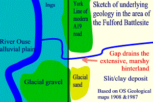
The ground created by the last ice age provided the surface on which the Battle of Fulford was fought.
The key feature is the rib of sand and gravel deposited at the face of the glacier as it melted. Its route is precisely marked by the line of the modern A19 road running roughly north-south. The competing armies would have approached the site along this route from the south. This geological wall has only been breached at one location near Fulford at Germany Beck.
Either side of this firm, elevated ground the land has been waterlogged since the ice retreated. The glacial deposit has determined the eastern course of the river Ouse which itself rests on the glacial material. The ground between the river and the glacial moraine is filled with alluvial material that is periodically refreshed when the river floods. This is the area of the Fulford Ings. The action of periodic flooding has also produced a firm path near the river bank as heavier material is left on the banks while fines are flushed back to the river.
To the east of the high ground is an extensive area of wet land. Over the centuries, much of this waterlogged land has been recovered. Most recently, the University of York was created after extensive hydrological work to drain the land. This area of silt and clay was deposited during the last glaciation and encircles the ground the to east of the battle site. While not impassable, there would be no easy route to bypass or outflank any blocking force at Fulford.
Germany Beck is the drain for this extensive area. At some stage the build-up of water on the area covered by the modern Walmgate Stray, Heslington and Fulford Damlands (Water Fulford) broke through the glacial bank to reach the Ouse. The size of the catchment area provides the flow necessary to cut, and then, keep this restricted route to the river open.
The only other area noted in geological surveys covers the area now covered by Fulford Cemetery. This deposit points to the weak point in the glacial material that was exploited by Germany Beck. At this point the melting glacier steps to the west. It would have provided a small area of firm, relatively high ground for the Viking army.
Sketch map based on information in 1908 and 1987 OS Geological Survey maps
 Some core samples have been taken from the Ings. The results should be published
in October 02
Some core samples have been taken from the Ings. The results should be published
in October 02